TIP Call for Projects - Data Resources
2022-2025 TIP Supplemental Wait List Call for Projects - CLOSED
All links and information below can be used to help you to fill out your applications. In addition to the information below, we've also included links to the Regional and appropriate Subregional Share applications. The current TIP waiting lists can be found here and the Call for Projects announcement is located here.
Datasets may not be available in all cases, so please supplement with local data, observations, and estimates when warranted. DRCOG hosts data on its Regional Data Catalog that is maintained and compiled from various sources. DRCOG offers its data in several formats, including shapefile, GeoJSON, WMS, and KML. Links to other partners with relevant data are provided for your convenience.
This webpage is organized by sections according to the TIP application.
Submittals
Regional Share
- Boulder County: SH-119 and 63rd Ave Transit Bypass Lanes
- Castle Pines: I-25 and Happy Canyon Interchange: Preconstruction Activities
- Lone Tree: I-25 and Lincoln Ave Interchange: Final Design
Subregional Share (note: some subregions were ineligible to submit for this call)
Adams County Subregion
Jefferson County Subregion
- Evergreen: Evergreen Lake Trail: Phase 2
- Golden: West Colfax Complete Streets: Phase 2
- Lakewood: Wadsworth & Morrison SB Accel Lane Operational Improvements
SW Weld County Subregion
Applications
- Regional Share application
- Subregional Share Applications
- Adams County Subregion
- Arapahoe County Subregion - no applications allowed
- Boulder County Subregion - no applications allowed
- Broomfield Subregion - no applications allowed
- Denver Subregion - no applications allowed
- Douglas County Subregion - no applications allowed
- Jefferson County Subregion
- SW Weld County Subregion
General Information
- Adopted 2020-2023 TIP Policy
- CDOT/RTD Concurrence Form
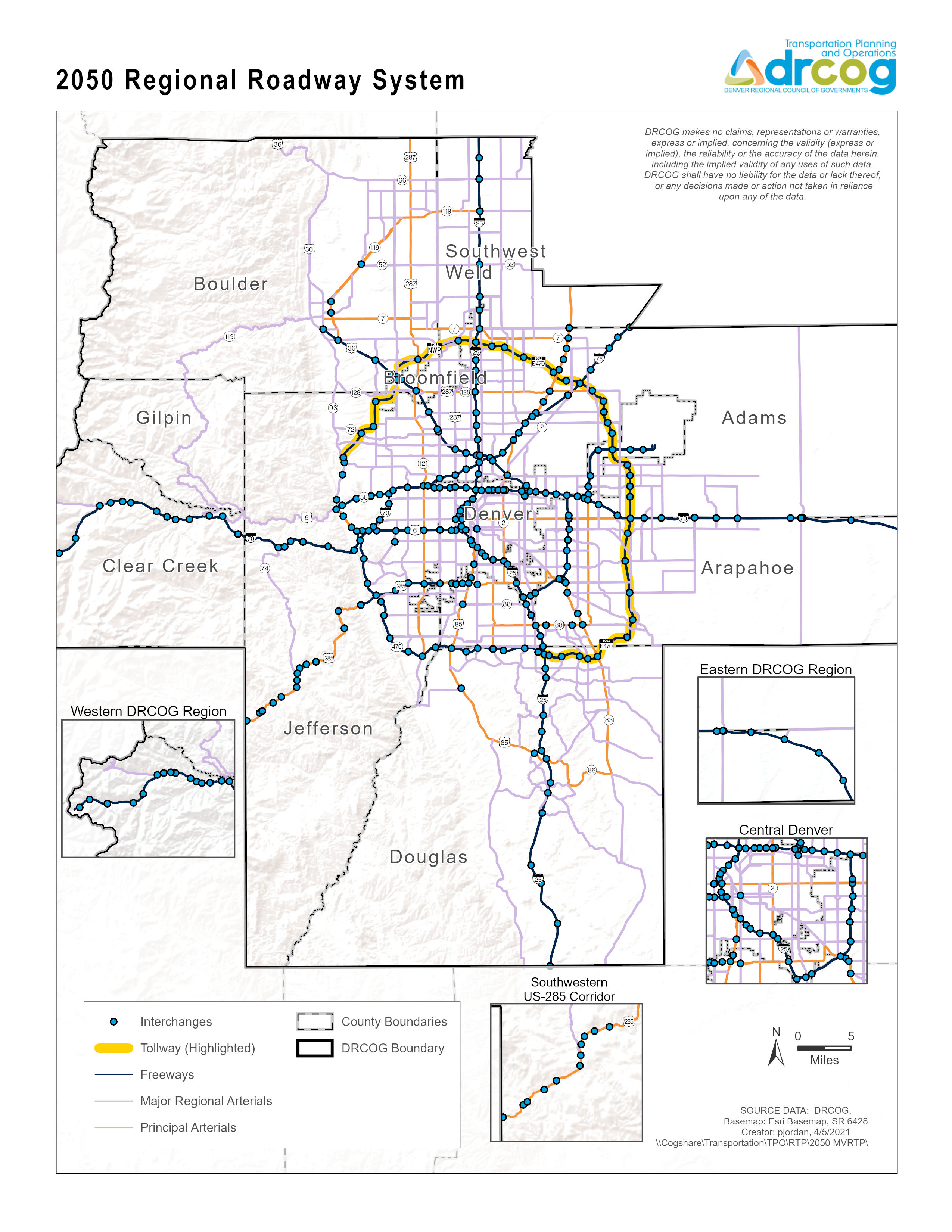
- Regional Roadway System
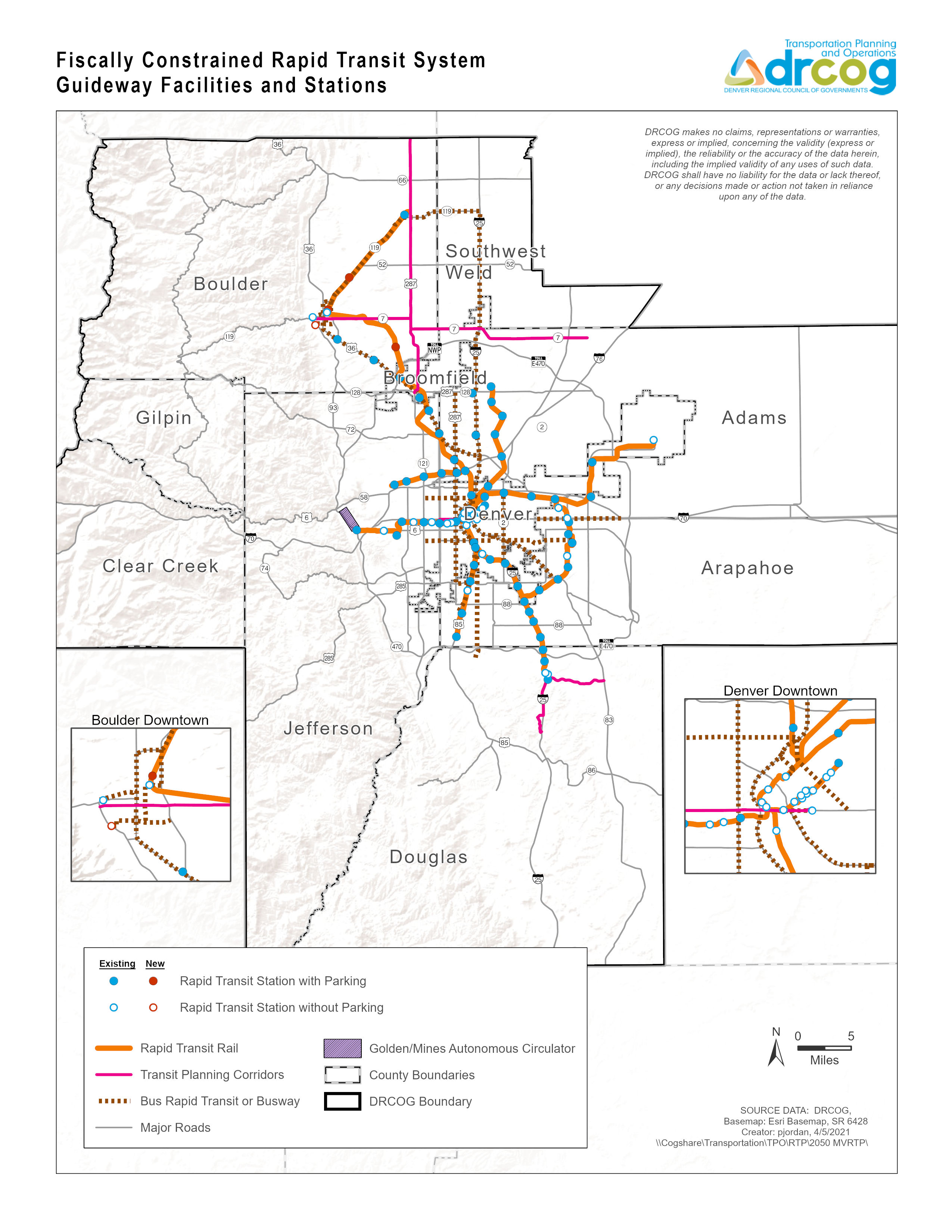
- Regional Rapid Transit Network
- Eligible Roadway Capacity Projects
- Eligible Regional Operational Project Locations (Regional Call only)
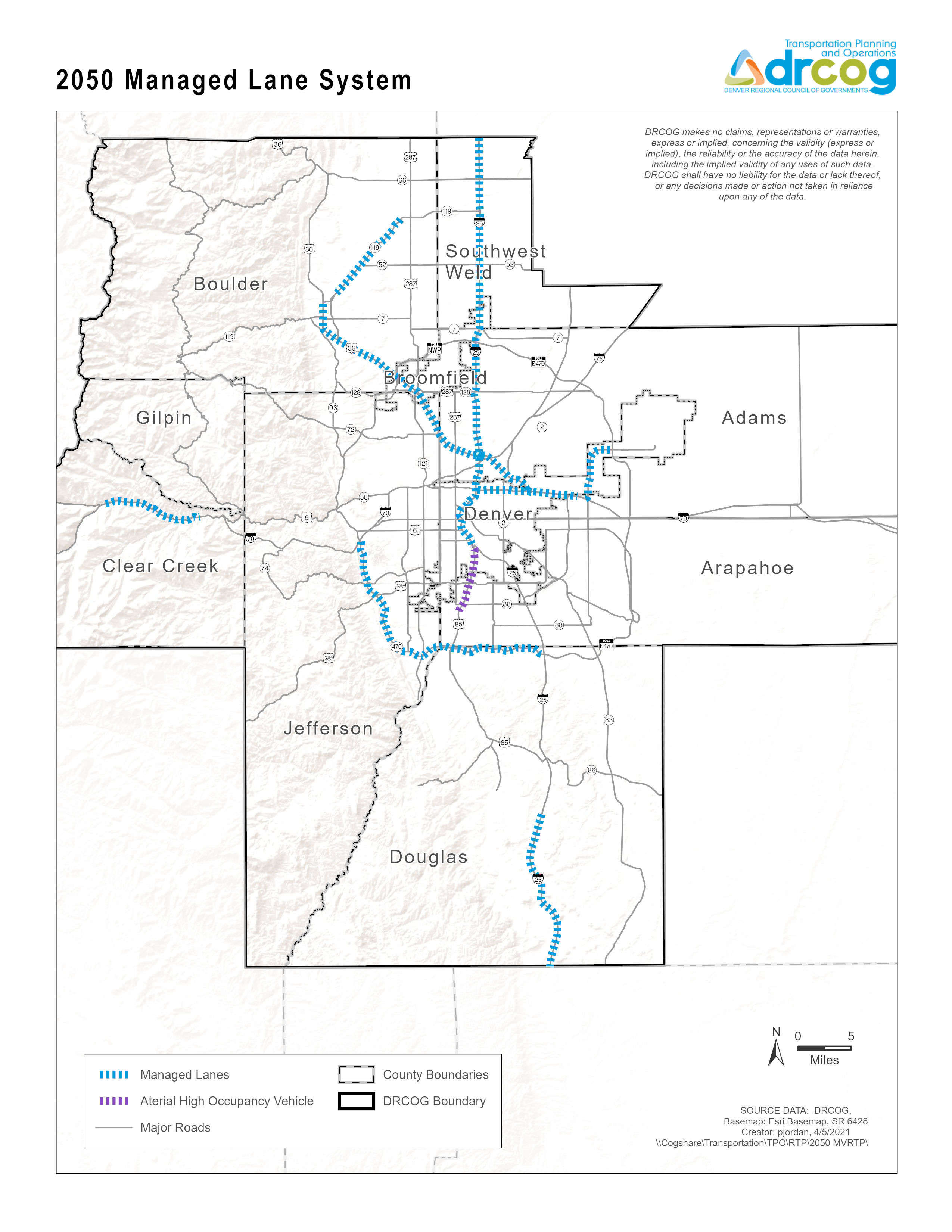
- Eligible Regional Managed Lanes System
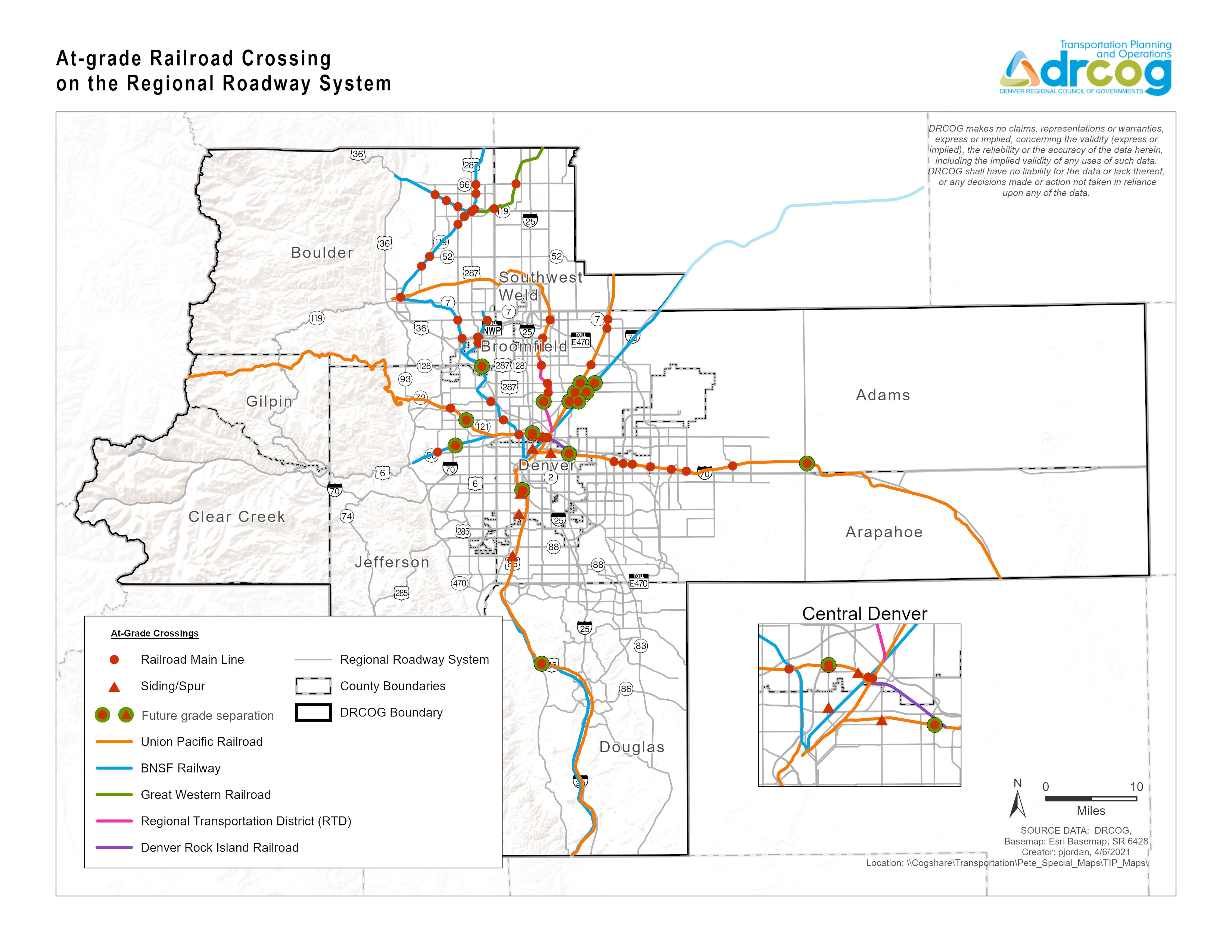
- At-Grade Railroad Crossings
- 2020-2023 TIP Training Presentations
- CDOT Local Agency Manual (revised July 2020)
- CDOT Forms
Part 2 - Evaluation Criteria, Questions and Scoring
A. Regional/Subregional Significance
Cross and/or benefit multiple municipalities
Cross and/or benefit another subregion
Connectivity to different travel modes
- Rapid transit system 2050
- Bicycle facility inventory
- Denver regional bicycle map (DRCOG web viewer)
- Regional Roadway System
- Sidewalk centerlines (2018) (Planimetrics project captures paved features as sidewalks)
- Trails centerlines (2018) Planimetrics project captures unpaved features as trails)
B. Metro Vision TIP Focus Areas
1. Improve mobility infrastructure and services for vulnerable populations (including improved transportation access to health services)
- Environmental justice analysis zones
- Rapid transit system 2050
- Bicycle share stations
- Vulnerable populations by tract (ACS 2015-2019)
- Vulnerable populations by block group (ACS 2015-2019)
- Nursing homes and assisted living facilities
- Nursing homes and assisted living facilities (DRCOG web viewer)
- Health facilities (CDPHE)
- Open data (CDPHE)
- Community facts (Shift Research Lab)
2. Increase reliability of existing multimodal transportation network
- Bicycle facility inventory
- Denver regional bicycle map (DRCOG web viewer)
- Bicycle share stations
- Regional Roadway System 2050
- Rapid transit system 2050
- Traffic counts
- DRCOG regional traffic counts (DRCOG web viewer)
- Open data (RTD)
3. Improve transportation safety and security
C. Transportation-Focused Metro Vision Objectives
1. Contain urban development in locations designated for urban growth and services
- TAZ level population and employment forecasts (2020)
- Generalized zoning (2017) (Strongly recommend using local zoning, comprehensive plans, facilities plans, and capital improvement plans)
- Special districts (DOLA web viewer and download) (May be helpful in identifying urban-level services not provided through a city or town.)
2. Increase housing and employment in urban center
3. Improve or expand the region’s multimodal transportation system, services, and connections
- Bicycle facility inventory
- Denver regional bicycle map (DRCOG web viewer)
- Regional Roadway System 2050
- Rapid transit system 2050
- Bicycle share stations
- Traffic counts
- DRCOG regional traffic counts (DRCOG web viewer)
- Open data (RTD)
4. Improve air quality and reduce greenhouse gas emissions
5. Connect people to natural resource or recreational areas
- Parks, recreation, and open space (2019)
- Bicycle facility inventory
- Denver regional bicycle map (DRCOG web viewer)
- Sidewalk centerlines (2018) (Planimetrics project captures paved features as sidewalks.)
- Trails centerlines (2018) (Planimetrics project captures unpaved features as trails.)
- Regional Roadway System 2050
- Rapid transit system 2050
- Open data (RTD)
6. Increase access to amenities that support healthy, active choices
- Parks, recreation, and open space (2019)
- Bicycle facility inventory
- Denver regional bicycle map (DRCOG web viewer)
- Rapid transit system 2050
- Bicycle share stations
- Sidewalk centerlines (2018) (Planimetrics project captures paved features as sidewalks.)
- Trails centerlines (2018) (Planimetrics project captures unpaved features as trails.)
7. Improve access to opportunity
- Community Anchor Institutions 2017 (Colorado Information Marketplace)
- Community facts (Shift Research Lab)
- Prekindergarten to college
- Regional Roadway System 2050
- Rapid transit system 2050
- Bicycle facility inventory
- Denver regional bicycle map (DRCOG web viewer)
- Bicycle share stations
- Sidewalk centerlines (2018)
- Trails centerlines (2018)
8. Improve the region’s competitive position
- Industry cluster concentrations (2020)
- TAZ Level Population and Employment Forecasts (2020)
- Employment Concentrations (2020):
Part 3 – Project Data
A. Transit use
- 2019 RTD Service Performance
- 2019 RTD Estimated Rail Station Activity
- TAZ Level Population and Employment Forecasts (2020)
B. Bicycle use
- Bicycle/Pedestrian Counts
- Non-motorized Traffic Data (CDOT web viewer)
- TAZ Level Population and Employment Forecasts (2020)
C. Pedestrian use
- Bicycle/pedestrian counts
- Non-motorized Traffic Data (CDOT web viewer)
- TAZ-level population and employment forecasts (2020)
D. Vulnerable populations
E. Travel delay
DRCOG staff may be able to use the Regional Travel Model to develop estimates for certain types of large-scale projects. Please contact Steve Cook for assistance.
- Traffic counts
- DRCOG Regional Traffic Counts (DRCOG web viewer)
- Traffic Data Explorer (CDOT web viewer)
F. Traffic crash reduction
H. Bridge Improvements
J. Disbenefits